


GPS Waypoint Finder

Deskripsi GPS Waypoint Finder
Uses the GPS sensor, Magnetic Field Sensor and Accelerometer to determine the distance and direction to a GPS waypoint. Does not need to be held level. Free & No Ads.
Normally a compass needs to be level to get the correct reading, but this app uses the accelerometer reading to convert the magnetic field reading back to the horizontal plane.
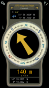
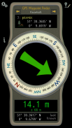
In addition to the direction and distance to the waypoint, a compass ring shows the current heading. North points to True North (i.e. The direction is corrected for the magnetic declination - the difference between magnetic north and true north).
The GPS reading and the time since that reading is shown at the bottom of the screen.
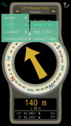
Use for geocaching, finding your car, hotel, or other locations.
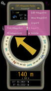
• Store up to 500 waypoints.
• Imperial or Metric units.
• Import and Export waypoints as GPX files.
Arrow colour changes to green at less than 30m and blue at less than 10m to make it easier for littler ones to identify that they've reached the waypoint.
Whilst walking, look where your going, not at the app or you might trip! The app tells you the direction of your destination, not how to get there.
Only as good as the sensors in your device. Use for Indication Only.
</div> <div jsname="WJz9Hc" style="display:none">Menggunakan sensor GPS, Magnetic Sensor Lapangan dan Accelerometer untuk menentukan jarak dan arah ke waypoint GPS. Tidak perlu diadakan tingkat. Gratis & No Ads.
Biasanya kompas perlu tingkat untuk mendapatkan bacaan yang benar, tapi aplikasi ini menggunakan pembacaan accelerometer untuk mengubah medan magnet membaca kembali ke bidang horizontal.
Selain arah dan jarak ke waypoint, cincin kompas menunjukkan pos saat ini. Poin utara ke True North (yaitu arah ini dikoreksi untuk deklinasi magnetik - perbedaan antara utara magnetis dan utara sebenarnya).
Pembacaan GPS dan waktu sejak membaca yang ditampilkan di bagian bawah layar.
Gunakan untuk geocaching, menemukan mobil Anda, hotel, atau lokasi lainnya.
• Menyimpan hingga 500 waypoints.
• Imperial atau Metric unit.
• Impor dan Ekspor waypoints sebagai file GPX.
Panah perubahan warna menjadi hijau kurang dari 30m dan biru kurang dari 10m untuk membuatnya lebih mudah bagi orang-orang littler untuk mengidentifikasi bahwa mereka telah mencapai waypoint.
Sementara berjalan, melihat di mana Anda pergi, tidak di app atau Anda mungkin perjalanan! Aplikasi ini memberitahu Anda arah tujuan Anda, bukan bagaimana untuk sampai ke sana.
Hanya sebagai baik sebagai sensor pada perangkat Anda. Gunakan untuk Indikasi Hanya.</div> <div class="show-more-end">
GPS Waypoint Finder - Versi 1.00
(04-04-2016)
GPS Waypoint Finder - Informasi APK
Versi APK: 1.00Paket: com.keuwl.gpswaypointsVersi Terakhir dari GPS Waypoint Finder


Aplikasi pada kategori yang sama


Anda juga mungkin suka...
Aplikasi pada kategori yang sama


